Hainan Island Travel Plan
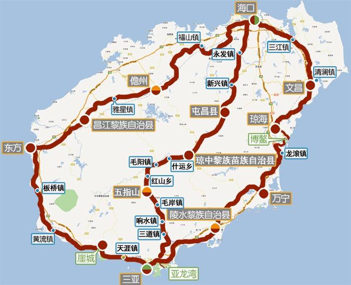
Hainan Island, the second largest island in China, has a large loop line of about 900 kilometers. The cycling route is very mature, with g223, g224 and g225 as the main national roads and some provincial roads. There are three main routes around the island, namely, the east line, the middle line and the west line. The three routes can be combined at will to complete the whole island or the peninsula. Most Qiyou roundabouts enter from the east line, west line or the middle line, and there are also some anticlockwise roundabouts, which enter from the west line and exit from the east line.
The Eastern Route
The east line starts from Haikou in the north, passes through Wenchang, Qionghai (Boao), Wanning and Lingshui to Sanya, with a total length of 420km, mostly along the coast. There are more natural landscapes and cultural attractions in the east of Hainan Island, and the tourism development is relatively perfect.
Haikou - Wenchang
Mileage: 85km
Duration: 7 hours
Accommodation: Wenchang is very convenient. Reference price: 50-80 yuan.
Camping: the coconut forest in the eastern suburb can camp. If you have good physical strength and have more time to go to Wenchang, you can continue to ride to Boao town for accommodation or camping.
Guidebook: Haikou City - maopo town (50km) - Wencheng town (75KM) - Wenchang City (85km) - alternative (coconut forest + 12km in the eastern suburb)
Road condition summary
All the way along S201 provincial road, two-way two lane asphalt road. The road condition is very good, mainly flat road, less gentle slope, and the overall journey is very easy.
Route point
Old arcade street in Haikou: located in the south of Renmin bridge in Haikou, it is a Nanyang style building built by returned overseas Chinese at the beginning of last century.
Mulan Lighthouse: at the northernmost end of Hainan Island, there is Mulan lighthouse known as the first tower in Asia.
Ancestral residence of Song family: located in ancient Luyuan village, ChangSa Town, Wenchang City, it is the residence of three generations of Sun Yat-sen's wife, Song Qingling, Gaozu, Zeng Zu and grandfather.
Tongguling: the westernmost corner of Hainan Island. You can see the beautiful moon bay here. On the way to Tongguling, you will pass Hainan Longlou space city.
Wencheng town Confucian temple: located in Wencheng Town, Wenchang City, founded in the Song Dynasty, known as "the first temple in Hainan", it is the most complete ancient architectural complex in Hainan.
Coconut forest in the eastern suburb: located in the coastal area of Dongjiao Town, Wenchang City, there is a saying that "Wenchang coconut is half Hainan, and Dongjiao coconut is half Wenchang". There are dozens of miles of coconut belt here, which is very suitable for camping.
Wenchang - Boao
Mileage: 62km
Duration: 6 hours
Accommodation: Boao town has developed tourism and relatively concentrated hotels. Reference price: 60-100 yuan.
Camping: Yudai beach can be camped.
Guidebook: Wenchang City Changpo town (37km) - Tanmen town (52km) - Boao town (62km) - alternative (yudaitan + 12km)
Road condition summary
From Wenchang City to Boao Town, there is still S201 provincial road, with smooth asphalt pavement. It should be noted that there is a three-way intersection 3 km away from Changpo Town, and there is a sculpture at the three-way intersection, which reads "Longwan Port Economic Development Zone". Turn left here, take the direction of Tanmen, turn out S201 provincial road, drive 2 km along the road, turn right to Boao Town, or take tayang town to Shangyong and then to Boao, but it will take a lot of distance.
Route point
Boao Forum for Asia: located on Dongyu Island, it has the world's most well protected River Estuary Wanquan River Estuary. It is the permanent site of the annual meeting of Boao Forum for Asia and the place to interpret Boao culture.
Boao jade belt Beach: located in the south of Boao Town, a naturally formed beach Peninsula, Wanquan River on the inner side, and the vast South China Sea on the outer side. If you go from Boao, you need to take a ferry to buy tickets for the scenic spot.
Boao - Lingshui
Mileage: 121km
Duration: 9 hours
Accommodation: concentrated in the branch road of Lingshui Wenjiao Road, reference price: 60-100 yuan.
Camping: Shimei Bay can be camped.
Guidebook: Boao town Wanning City (60km) - Xinglong (82km) - Lingshui Li Autonomous County (121km)
Road condition summary
Go out from Boao and walk along Yingbin Road (S219). After passing the Dale bridge, turn right at lanpei village and take x428 County Road (this road is about ten kilometers longer than that of S219). Finally, join the national highway g223 near Longkun town. The road condition is mainly asphalt road, which is in good condition. After going out of Xinglong, it starts to climb the first hill around the island: 3km uphill, 140m fall, the average gradient is about 4%, the maximum gradient is 12%. After crossing the hill, you can reach Lingshui County soon.
Route point
Diaolo mountain: diaolo mountain forest park has a lot of natural tourism landscapes, as well as the famous Fengguo mountain waterfall group and the beautiful rural scenery of South China.
South Bay Monkey Island: surrounded by the sea on three sides, located on the South Bay Peninsula of Lingshui County, it is the only island type Macaque Nature Reserve in China and the world. There are more than one thousand macaques in 21 groups on the island, so people call it "Monkey Island".
Lingshui - Sanya
Mileage: 70km
Duration: 8 hours
Accommodation: Sanya has a lot of accommodation with uneven prices. The author recommends Tianya town near Sanya. There are many seaside tours here. The reference price is 80-100 yuan. There are Tianya Haijiao and Nanshan scenic spots nearby. The transportation is very convenient.
Lu Shu: Lingshui Li Autonomous County Haitangwan town (46km) - Sanya City (70km) - alternative (Tianya town + 20km)
Road condition summary
This section runs along national highway g223, with asphalt pavement and good road condition. After passing Haitangwan Town, there is a small mountain road, with an uphill of 3km and a drop of 90m. It's easy to ride all day, and there's enough time to park, watch and rest.
Route point
Haitang Bay: with Yalong Bay, Dadong Bay, Sanya Bay, Yazhou Bay side by side Sanya five famous bays. Relatively quiet, suitable for passing by.
Wuzhizhou Island: near Haitang Bay, the sea area is clear and transparent. There is a well protected coral reef, which is the best diving base in China.
Yalong Bay: it has the most charming Bay and beach in China.
Luhuitou: overlooking Sanya, you can climb high and look at the sea, or watch the sunrise and sunset.
Tianya Haijiao: the most famous tourist attraction in Hainan Province.
The Western Route
The west line starts from Haikou in the north and reaches Sanya through Danzhou, Dongfang and Yacheng, with a total length of about 450km. Compared with the east line, it is a bit barren and backward, but its natural scenery is no inferior to that of the east line. It is another tropical landscape. At the same time, the original flavor without modification can let you experience more people's customs of Hainan Island.
Tianya - Oriental
Mileage: 147km
Duration: 10 hours
Accommodation: Dongfang City, reference price: 40-80 yuan.
Camping: yuyuyuzhou
Guidebook: Tianya town Yacheng town (22km) - Huangliu town (70km) - Dongfang City (147km)
Road condition summary
After leaving Sanya City in the west, it entered the National Highway (g225) of the west line, with asphalt pavement throughout the whole process, mainly flat road, good road condition and few uphill and downhill.
Route point
Nanshan: the southernmost mountain in China. It's said that master Jianzhen, a famous monk in Tang Dynasty, built a Buddhist temple here to preach.
Yazhou City: Yazhou was built in the southern and Northern Dynasties, and expanded after the Song Dynasty. Now the gate has been restored, with a long history and a large number of historic sites.
Yingge sea salt field: located in Ledong County, facing the sea and backed by Jianfengling, it is the largest sea salt field in Hainan Island.
Windmill power plant: before arriving at Gancheng Town, a large number of windmill generator units can be seen towards the south.
Yuyuyuzhou: on the southwest beach of Basuo Town, Dongfang City, there is yuyuyuzhou lighthouse, which is an important navigation mark in Beibu Gulf. Free scenic spot, shallow water and fine sand, ideal natural seaside swimming pool, suitable for camping.
Dongfang - Danzhou
Mileage: 124km
Duration: 10 hours
Accommodation: it is distributed in Jiefang Road and nearby alleys in Danzhou City. Reference price: 60-100 yuan.
Guidebook: Dongfang City - zhehe town (40km) - Rongbang township (76km) - Danzhou City (124km)
Road condition summary
The line of this section is still running along g225 national highway, with few cars, but there are many washboard roads along the line, which are slightly tossed.
Route point
Tropical Botanical Garden: tropical rainforest scenery.
Yunyue Lake: the lake formed by the reservoir, which once had a park, has a good scenery.
Danzhou - Haikou
Mileage: 133km
Duration: 9 hours
Accommodation: there are many youth tours in Haikou City. The reference price of beds for youth tours is 40-50 yuan. There are also many other hotels of different grades.
Guidebook: Danzhou City Fushan town (66km) - old town (107KM) - Haikou City (133km)
Tips: there are two schemes from Danzhou to Haikou
Scheme 1: National Highway g225 in the whole process.
Scheme II: part of national highway g225, with Zhongxing Town, Shankou Township and Chengmai County in the middle.
In terms of road conditions, it is recommended to take scheme I and scheme II, in which many township roads and villages have access to small roads. Although they are near, the road conditions are relatively poor.
Road condition summary
G225 National Highway in the whole process is in good condition and relatively flat. It is basically a gentle washboard road, but the overall downhill is more.
Route point
Shishan Volcano Group National Geopark: a quaternary volcano group composed of 40 dead volcanoes. Riders who are interested in geology and volcanoes can go and have a look.
The Middle Route
The middle line starts from Haikou in the north, passes through Tunchang County, Qiongzhong County, Wuzhishan City and Baoting county and reaches Sanya. The economy is relatively backward. It is mainly inhabited by Li and Miao compatriots and basically maintains its own living habits. The total length is about 280km, due to the heavy physical consumption of mountain climbing. The route of this section is designed in the direction of Sanya Haikou, and it can also be adjusted to the direction of Haikou Sanya as required.
Sanya - Wuzhishan
Mileage: 82km
Duration: 8 hours
Accommodation: accommodation in Wuzhishan City is distributed on both sides of national highway g224 and the surrounding roads. Reference price: 40-80 yuan.
Guidebook: Sanya Xiangshui town (54km) - Wuzhishan City (82km)
Road condition summary
Today, the whole line goes along g224 national highway, with good road conditions. After passing shuangben, it starts to climb the first mountain of this day, with a continuous uphill of 3.7km, reaching the top of Ganshi ridge, then downhill of 6.5km to Chitian reservoir, and then to Xiangshui Town, there is no big uphill. After passing Xiangshui town for 2km, it starts to climb the main uphill section of this day, with continuous long slope of about 8.5km, and then the altitude changes slightly.
Route point
Penang Valley: a living fossil of Hainan folk culture. You can experience the most primitive ethnic culture of Li and Miao people here. It is located in Ganshiling nature reserve. The ticket is 125 yuan.
Wuzhishan - Tunchang
Mileage: 126km
Duration: 10 hours
Accommodation: the accommodation in Tunchang County is mainly distributed in the central area of the county around the g224 line. The reference price is 30-80 yuan.
Guidebook: Wuzhishan City - Tuoling viewing platform (10km) - Maoyang town (24km) - Qiongzhong County (74km) - Tunchang County (126km)
Road condition summary
All day along g224 National Road, after leaving Wuzhishan City, you start to climb the mountain. The length is about 10km, and you can get to the viewing platform of Tuoling. You can look back at the whole picture of Wuzhishan City. After turning over, you can get to the downhill road of about 14km, and then you can get to Maoyang town. From here, g224 starts to turn from the north to the East. After about 50km ups and downs, it reaches Qiongzhong. After that, there are basically no mountains.
Route point
Yinggeling: Yinggeling area is the largest and contiguous natural forest distribution area in South China, with tropical rain forest as the main part. Its original tropical rain forest is the most well preserved with diverse biological species.
Wuzhishan: located in the middle of Hainan Island, Wuzhishan is covered with tropical primeval forests, which are endless and winding. The main rivers in Hainan all originate from this place, and the mountains, light and water add radiance to each other, forming a unique and magnificent scenery.
Mount Limu: the holy land of Li nationality, the ancestor of Li people. It has four seasons like spring, warm in winter and cool in summer, with an average annual temperature of 22.5 ℃. It is a resort for adventure tourism, sightseeing and national religious activities.
Tunchang - Haikou
Mileage: 91km
Duration: 7 hours
Road book: Tunchang County Xinxing town (17km) - Yongxing Town (67km) - Haikou City (91km)
Road condition summary
This day, continue to move along g224 to Haikou, with good road conditions throughout the day, mainly undulating Road, without large altitude drop change. The whole day mileage is 90km, which is relatively easy.
Route point
Tropical wild fauna and flora garden in Hainan: the largest lion tiger animal and tiger lion group in the country, with natural scenery and natural forests, is China's only natural oxygen bar with a panoramic view of the tropical rain forest ecosystem and concentrating the essence of Hainan Island flora and fauna.
- Link : https://www.zdyla.com/en/post/cycling-around-the-hainan-island.html
- Copyright Notice : Unless otherwise stated, please contact the author for authorization and indicate the source!