Memories of Tibet (14) : The Third Pole
Considering the determined destination, according to the estimation of the driver's master, you can get more sleep the next morning, so it's 9:30 in the morning when you finish breakfast and gather.
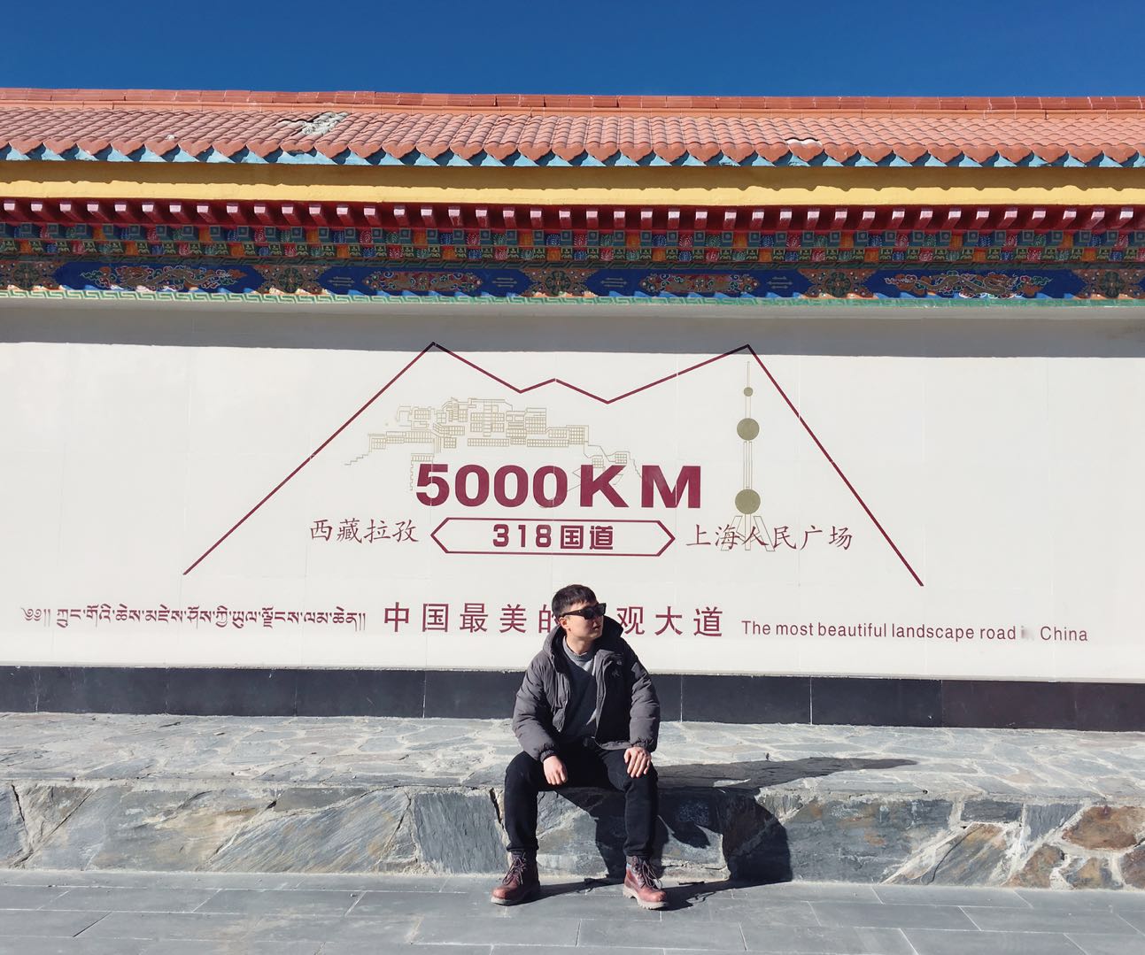
It's sunny in the morning. Everyone is on the road with great enthusiasm. At more than 11:00, we arrived at the 5000 km milestone of national highway 318 in Jiangzi county. The two teams of people have rushed out of the two traveling vehicles one after another. Everyone is very excited. They use all kinds of moves to take pictures of themselves and together. Everyone knows how legendary the G318 road is. It is also known as the most beautiful landscape road in China.
Continue to drive along G318, the road in front of you is becoming wider and wider, the surrounding mountains are gradually far away from us, standing up slowly like giants in the distance, becoming tall and straight. The blue sky is more and more bright, no cloud shadow can be found, and the sun irradiates wantonly, which is extremely dazzling.
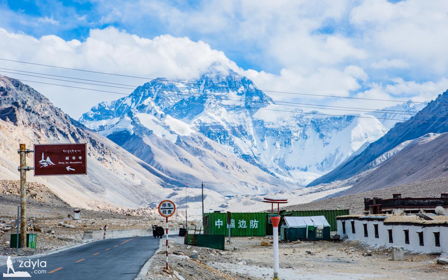
When we arrived at baiba village, Dingri County, it was more than 2:30 p.m., and the wasteland in front of us began to be replaced by houses. The car was parked in front of a big stone with Everest National Park engraved on it.
Not far away on the stone heap and steps, several children sat up and down. Seeing a car passing by, they were excited and gradually we approached. As soon as the door opened, they all came up, and we immediately became nervous and at a loss. When we were shocked, we saw that each of them had a small dark head and stretched out a small hand to eat.
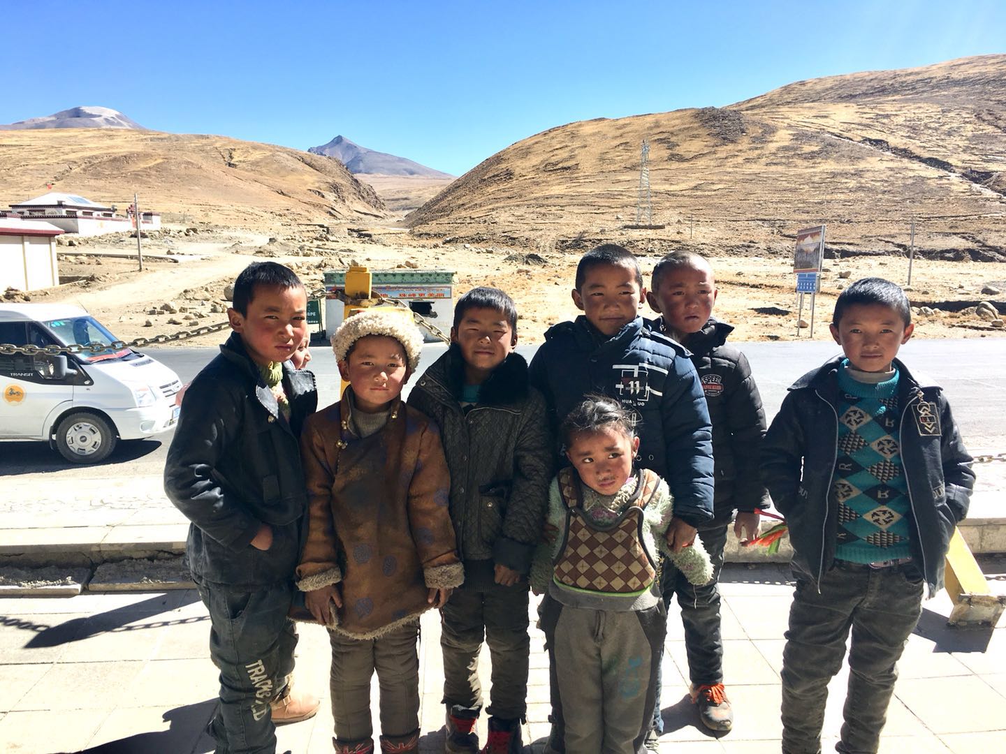
I have an idea and say to them, all in line on the steps, I will send you one by one. I didn't expect that they were so simple and lovely. They hurriedly lined up on the steps and waited quietly
Fortunately, I bought many biscuits and chips in the supermarket last night. There was no one to fight for them. What I am most curious about is that when they get snacks, they are not ready to eat immediately, but handed over to a slightly older child
I asked the big boy if you bullied other little friends and took away their snacks. He quickly explained that, no, I am the leader, and I will distribute it equally to everyone! I don't feel relieved to ask the other children next to me if this is the case. They all nodded and said yes. Seeing that there are no other children crying shows that the leaders are telling the truth and that they are a united little organization. It's so interesting
We gathered together happily to take photos, and they also actively cooperated. When the shutter was pressed, I felt the happiest moment in this trip to Tibet.
We are a little reluctant to leave. Seeing these lovely children, we begin to feel sorry for them. Except for ordering snacks with tourists, it may be difficult for them to eat and wear. At the time of parting, each of them held out a small black hand to wave goodbye to us, and kept shouting, goodbye, goodbye

After half an hour's winding mountain road, we climbed up the Everest observation platform. The wind on the top of the mountain was extremely strong. The prayer flags nearby were sounded by the hunting of the wind, and the cars that had stopped steadily were vibrated by the wind. When we are close to the edge of the viewing platform, the broad and rough landscape is in front of us. For a moment, it shocks all people. I even feel that my pupils are expanding involuntarily, and I want to put all the present in front of us
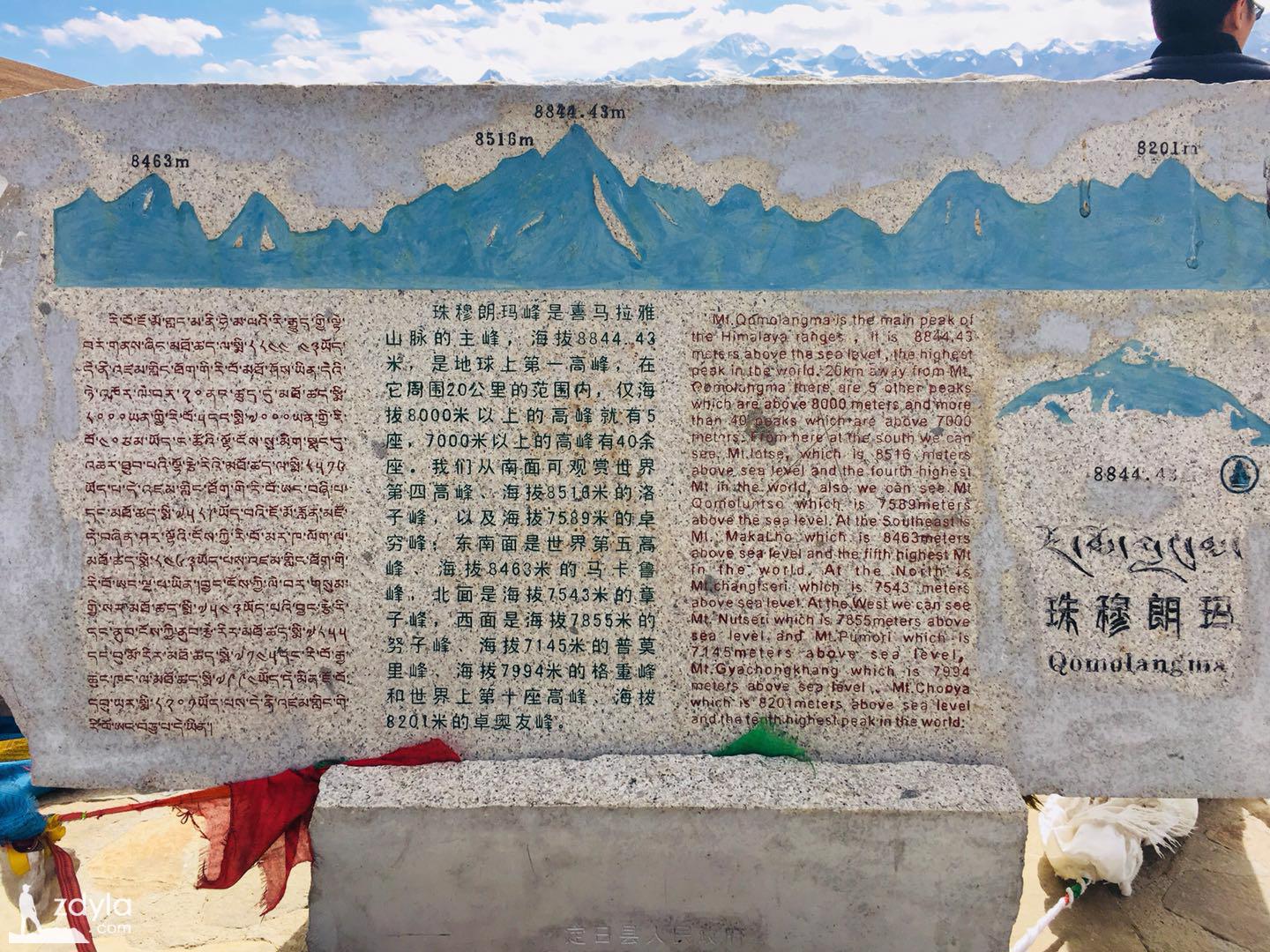
At the end of the sky, a series of rolling snow mountains stand like the gods of war in the wind and snow, holding up the heaven and earth. Among them, the highest is Mount Everest, which is the main peak of the Himalayas, with an altitude of 8844.43 meters. It is the first peak on the earth. Within the range of 20 kilometers around it, there are only five peaks with an altitude of more than 8000 meters, and more than 40 peaks with an altitude of more than 7000 meters. In the southwest, there are the fourth highest peak in the world, Luozi peak with an altitude of 8516 meters, and Zhuoqian peak with an altitude of 7589 meters. In the southeast, there are the fifth highest peak in the world, Makalu peak with an altitude of 8463 meters, Zhangzi peak with an altitude of 7543 in the north, Nuzi peak with an altitude of 7855 meters, pomori peak with an altitude of 7145 meters, gechong peak with an altitude of 7994 meters, and the tenth highest peak in the world The 8201 meter zhuoyou peak.
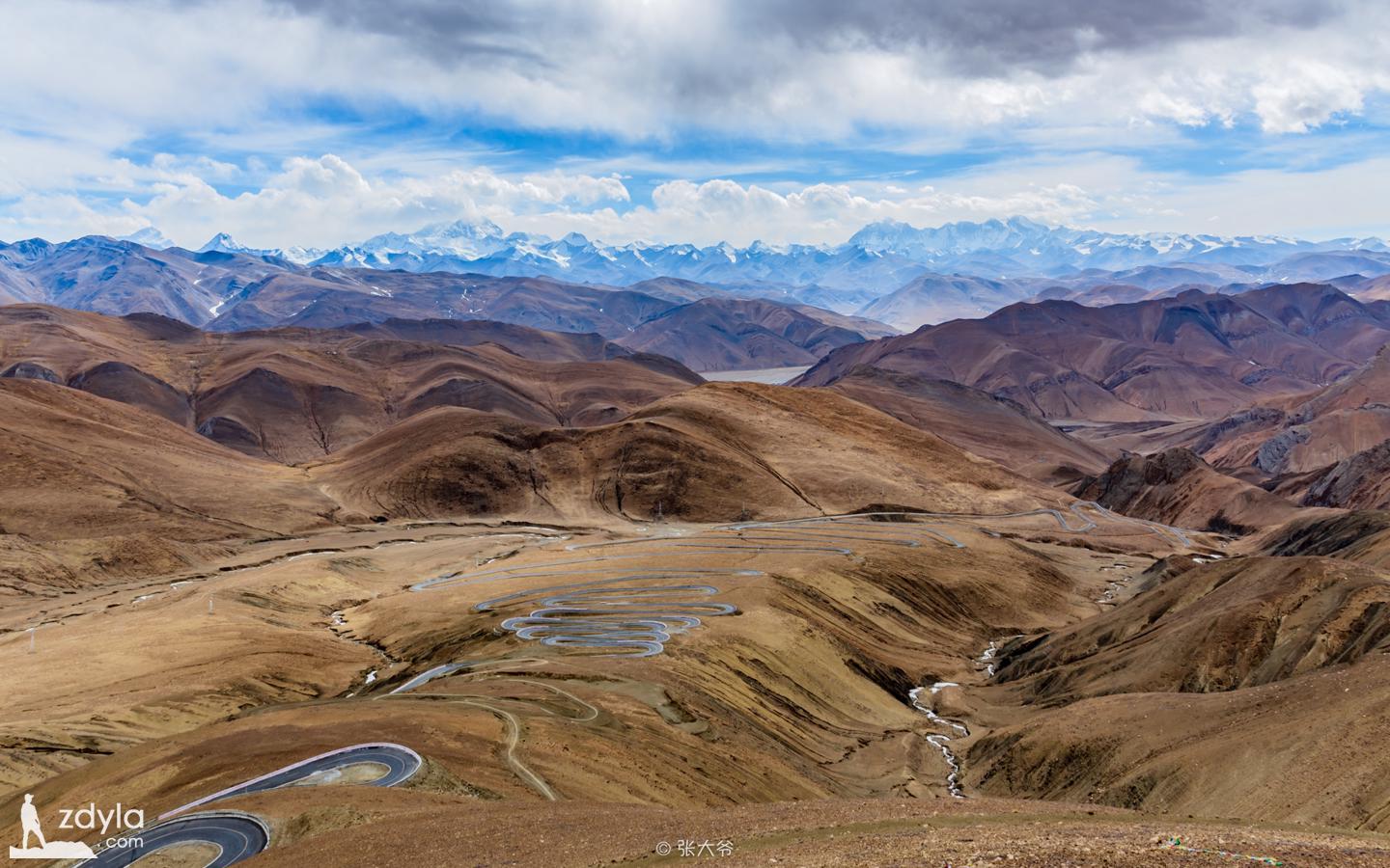
At present, mount JIAWULA, with its rolling, crisscross gullies, winding rivers and highways, is so small and tiny. A magical small mountain, like the earth open an eye, pay attention to the vicissitudes of the world
Standing here, no matter how tall human beings are, they are so small. Under the shock of nature's primitive temperament, people can't help but feel short of breath and their legs are soft. Only when they crawl on the ground can they relieve their chest pressure
The viewing platform is an hour or two away from the Everest base camp. We have to get there before dark, hoping to take a chance to catch the golden Everest dyed by the sunset when the sun sets.
Everest base camp refers to the living area set up to watch the environment of the core area of Everest. There are two areas in China. The west slope base camp is located in zhaxizong Township, Dingri County, Xigaze Prefecture, Tibet Autonomous Region, and the east slope base camp is located in gamagou District, Qudang Township, Dingri County, with an altitude of 5200 meters and a straight-line distance of about 19 kilometers from the top of Everest peak. It is a national AAAAA level tourist area. Nepal also has its base camp.
At 5:30 p.m., we finally arrived at the Everest base camp in the gamagou area. Outside the base camp, the famous Rongbu temple is located at the top of Zhuoma mountain on the East and west side of rongbugou, which is 5154 meters above sea level, high and cold, the highest temple in the world.
The flat land not far from the temple is empty, because it is too cold in winter to camp here, so they all withdraw, leaving only the lattice made of stone.
Four kilometers further, you can see the monument of Everest base camp, which is 5200 meters above sea level. Usually, there should be armed police in front of the monument, but we didn't see it, maybe because of the cold winter. Looking up again, it is the world's highest peak, Mount Everest.
The huge mountain in front of us is shining blue under the blue sky. Each of us is very excited but full of awe. We look up at Everest and can't help but show our respect. There is no doubt that it is a holy mountain. Every passing white cloud will give a revered kiss before leaving.

We are lucky. Between the clouds, we still have the chance to see the top of Everest. But unfortunately, at sunset, the clouds suddenly increased and soon filled the whole sky. There was no possibility of sunshine, so we had to leave.
We have too much to learn about Everest.
In 1258, the unearthed "Lotus relic" called Mount Everest "raqi", and Sangji jianzan, a monk of Gaju school, called Mount Everest "snow at most" in "mirarepa road songs". In 1717, Emperor Kangxi of the Qing Dynasty sent personnel to map the map of the emperor's public opinion, which was named "zhumlangmaalin". "Alin" is Manchu, which means "mountain". In Tibetan, "jumlangma" means "Everest". There are different opinions on the pronunciation and meaning of "Everest". A common saying is "goddess of the earth". "Zhumu" (ཇོ་མོ) means goddess, and "Ma" is a nominal negative part of speech. The meaning of "Lang Ma" is different: one is the abbreviation of "Miyo Lang Sangma" (Zhenhui tiannv), the heavenly daughter who lives on this peak in the Tibetan Buddhist legend, one is "cow" and the other is "mother elephant". In 1951, Prince Ju of geography proposed that the name of Mount Everest should be used. In 1952, the Ministry of interior of the people's Republic of China adopted its proposal to name Mount Everest. In 2002, the people's Daily published an article saying that the English name "Mount Everest" used in the western world should be the Tibetan name "Mount Qomolangma".
Mount Everest attracts many climbers. There are two main climbing routes: one starts from the southeast of Nepal, passes through the South depression between Luozi peak and climbs to the top, which is called "standard route"; the other starts from the north of Tibet, passes through the north depression between Zhangzi peak and climbs to the top. Climbing from a standard route is not a high challenge to mountaineering technology, but the risks of this route include avalanches, falling valleys, mountain sickness, frostbite and the risk of passing through the kunbu icefall. As of 2016, there were more than 200 bodies on the mountain, some of which became landmarks.
According to meteorological records, the lowest temperature at the top of Mount Everest is - 60 ° C, the lowest monthly average temperature is - 35 ° C, and the annual average temperature is - 29 ° C. referring to the Arctic and Antarctic, it is also known as the "third pole of the world".
- 本文链接: https://www.zdyla.com/en/post/about-xizang-14.html
- 版权声明: 本博客所有文章和照片除特别声明外,转载请联系作者获取授权,并请注明出处!